GPS
How does the GPS work? Learn more about Global Navigation Satellite Systems (GNSS) and their operational principles.
Track the GPS satellites that are flying above your satellite simulator.
Jump to Satellite Simulator activity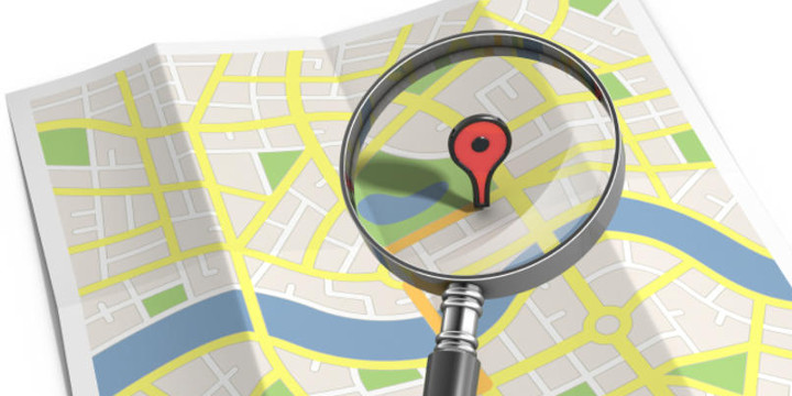
How does the GPS work? Learn more about Global Navigation Satellite Systems (GNSS) and their operational principles.
Track the GPS satellites that are flying above your satellite simulator.
Jump to Satellite Simulator activity
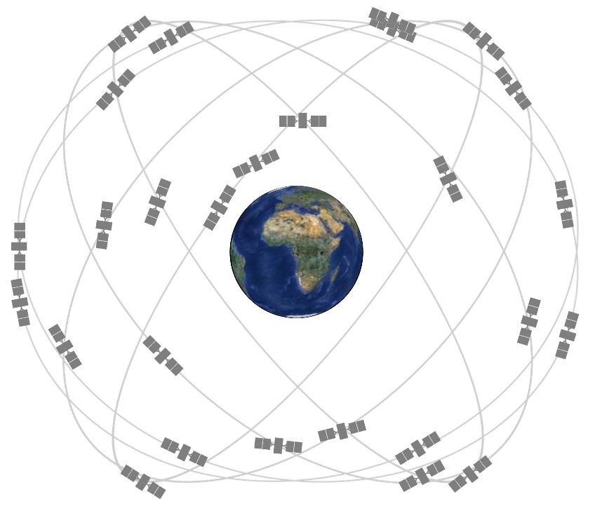
There are many different types of satellites which are used for different purposes, for example, navigation satellites, earth observation satellites, communications satellites, weather satellites, space telescopes, and others. The GPS (Global Positioning System) is the most popular Global Navigation Satellite System (GNSS) but there are other global navigation satellite systems like the Galileo, GLONASS, or Beidou. Each of these systems is composed of dozens of satellites flying in well-known orbits around the Earth.
You probably heard about the GPS but do you actually know how it works? Today, every smartphone carries a small GPS receiver inside that allows the determination of the position with an accuracy of a few meters. This receiver collects signals from multiple satellites and then calculates its current position from the satellites’ signal. The GPS receiver does not transmit any signal to the satellites, it only receives the information from the satellites.
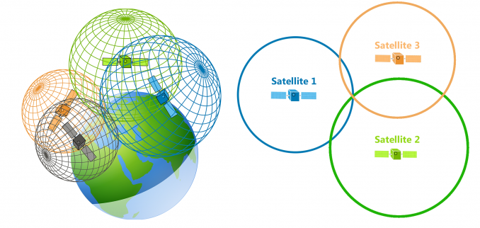
Trilateration allows the mathematical determination of the current position. Data from one satellite pinpoints a position to a large area of the earth's surface. Adding data from a second satellite narrows the position down to the region where the two spheres of satellite data overlap. Adding data from a third satellite provides a relatively accurate position. The use of data from more satellites enhances precision, so GPS receivers routinely track four to seven satellites and sometimes even more.
Although GPS is the most popular global navigation satellite system, there are other systems developed by other nations as mentioned before. For example, the GLONASS from Russia, the BeiDou from China, and the recently developed Galileo from the European Union. Galileo has the potential to offer position accuracy of a few centimeters! All these constellations have dozens of satellites in Medium Earth Orbit (MEO) at about 20 000 kilometers of altitude.
In Galileo, each satellite has a passive hydrogen maser clock. This is an atomic clock which uses the ultra-stable 1.4 GHz transition in a hydrogen atom to measure time to within 0.45 nanoseconds over 12 hours.
Gravity curves space and time according to Einstein's general relativity theory. This translates into having a GPS satellite clock advancing faster than a clock on the ground by about 38 microseconds per day. If these effects were not properly taken into account during development, a navigational fix based on the GPS constellation would be wrong just after 2 minutes.
In 2014, two Galileo satellites were inserted in wrong orbits. Unfortunately, this mistake made them inoperable as part of the Galileo satellite constellation and therefore they were repurposed to test Einstein’s General Relativity theory with higher accuracy. Scientists turned a mission failure into an opportunity for further scientific experimentation.
Celestial bodies have been mapped and tracked for many thousands of years. The Horizontal Coordinate System is a celestial coordinate system were an observer on Earth can track an object flying in space using only two coordinates: Azimuth, and Elevation (sometimes named Altitude like in the image below). [1]

This coordinate system divides the sky into the upper hemisphere where objects are visible, and the lower hemisphere where objects cannot be seen since the Earth obstructs vision. Using the Elevation and Altitude, the satellites can be plotted on a two-dimensional projection like the one below.
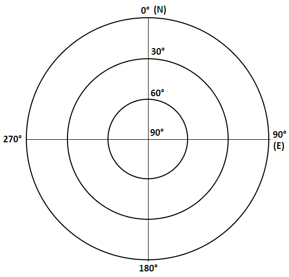
The Elevation (altitude) is the angle between the satellite and the observer's local horizon so, for example, a satellite flying perfectly above the observer will be at 90 degrees elevation and it would be represented in the center of the plot. The Azimuth is the angle of the object around the horizon, which is measured from the north increasing towards the east.
The GPS Tracker instrument is capable of generating such plots with the GPS satellites in view data. This allows the visualization of the GPS satellites' location around our satellite. The instrument also displays other data that is made available by the GPS unit such as the latitude, longitude, and altitude of our satellite.
1. Open the AstroMissions App and go to the “Satellite Simulator” tab. Press “Launch!”:

After pressing the button, the satellite simulator will start and a set of instruments will be displayed on the right side.
2. Press the “GPS Tracker” instrument in order to start it:
The “GPS Tracker” instrument will initialize. The “Console View” will be presented during initialization and it will switch automatically to the “Services View” after initialization.
Interesting fact: All GPS terminals used by civilians have something called the COCOM limits which prevent GPS receivers from being used at an altitude above 18 kilometers or at a speed above 1000 knots. These limits were set in place to prevent its use in ballistic missiles without having a special permission. This means that in order to use a GPS unit in space (for example by other satellites), it is necessary a special GPS receiver without these limits.
Fortunately, the GPS unit in our satellite simulator does not have the COCOM limits. This means that we can use it operationally in space where the satellite travels at high velocity.
3. Go to the Parameters Dashboard:
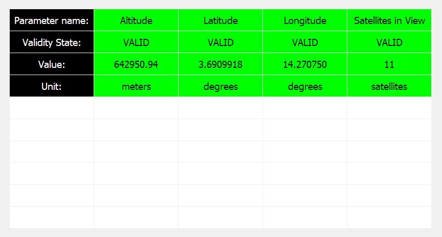
We can visualize the parameters available on the GPS Tracker instrument. These are also available directly on the Satellite Simulator parameters list. The parameters will switch color every time a new parameter value is received. The corresponding value of the parameter is on the “Value” field. For example, in the picture above, the altitude is of 660’670 meters or about 660 kilometers.
The GPS satellites fly at a much higher altitude than our satellite simulator. The GPS satellites fly at an altitude of about 20'200 kilometers. This means that our satellite can track the GPS satellites that are above itself and get a position fix from them.
4. Scroll down to the end of the GPS Tracker instrument panel and on the bottom, you will find two buttons. Click on the “View Satellite Controller” and then on the “Switch to: Advanced Mode”:
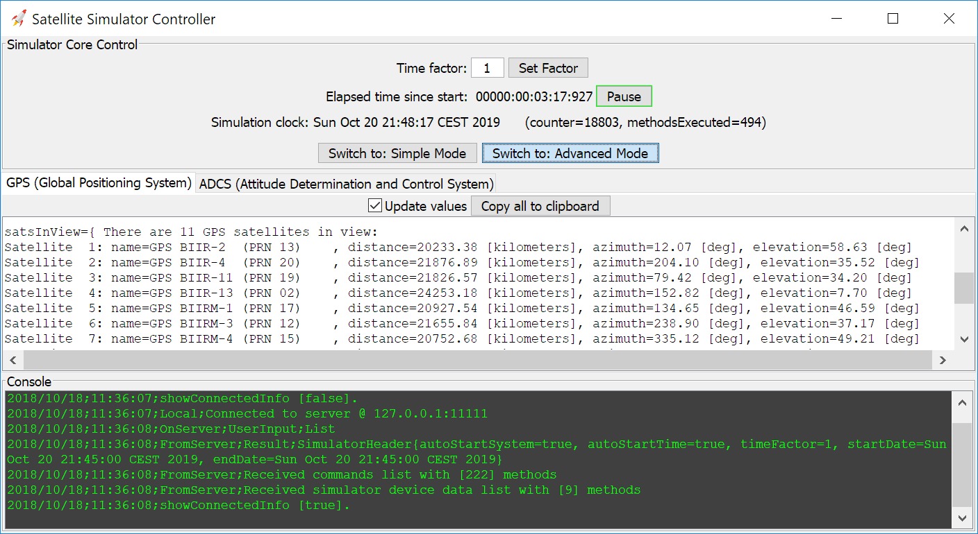
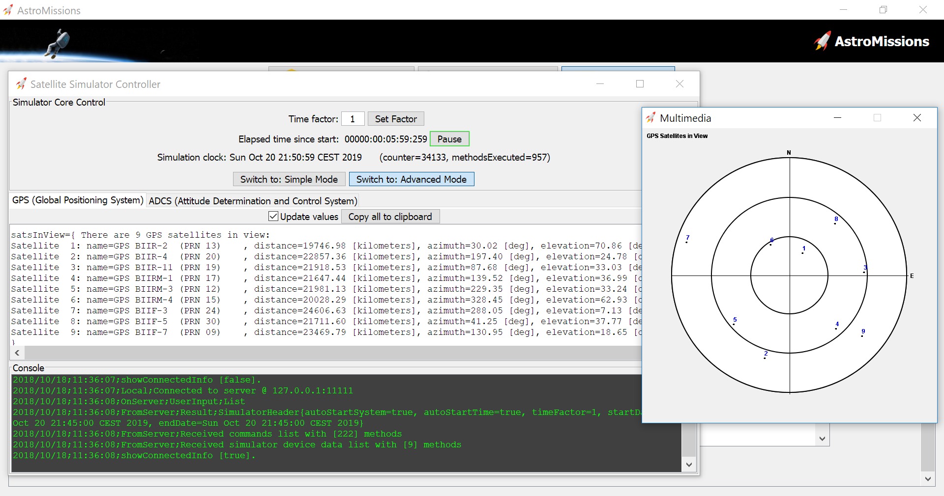
In the Satellite Simulator Controller, we can go to the GPS tab and visualize the data of the GPS satellites in view. These are the satellites from the GPS constellation that are flying above our satellite and we can see their respective name, their PRN (pseudorandom noise number), the distance to our satellite, and also the azimuth and elevation.
5. Go back to the “GPS Tracker” instrument panel, and then to the “Multimedia Inbox”. Click on the “Satellites Plot”:
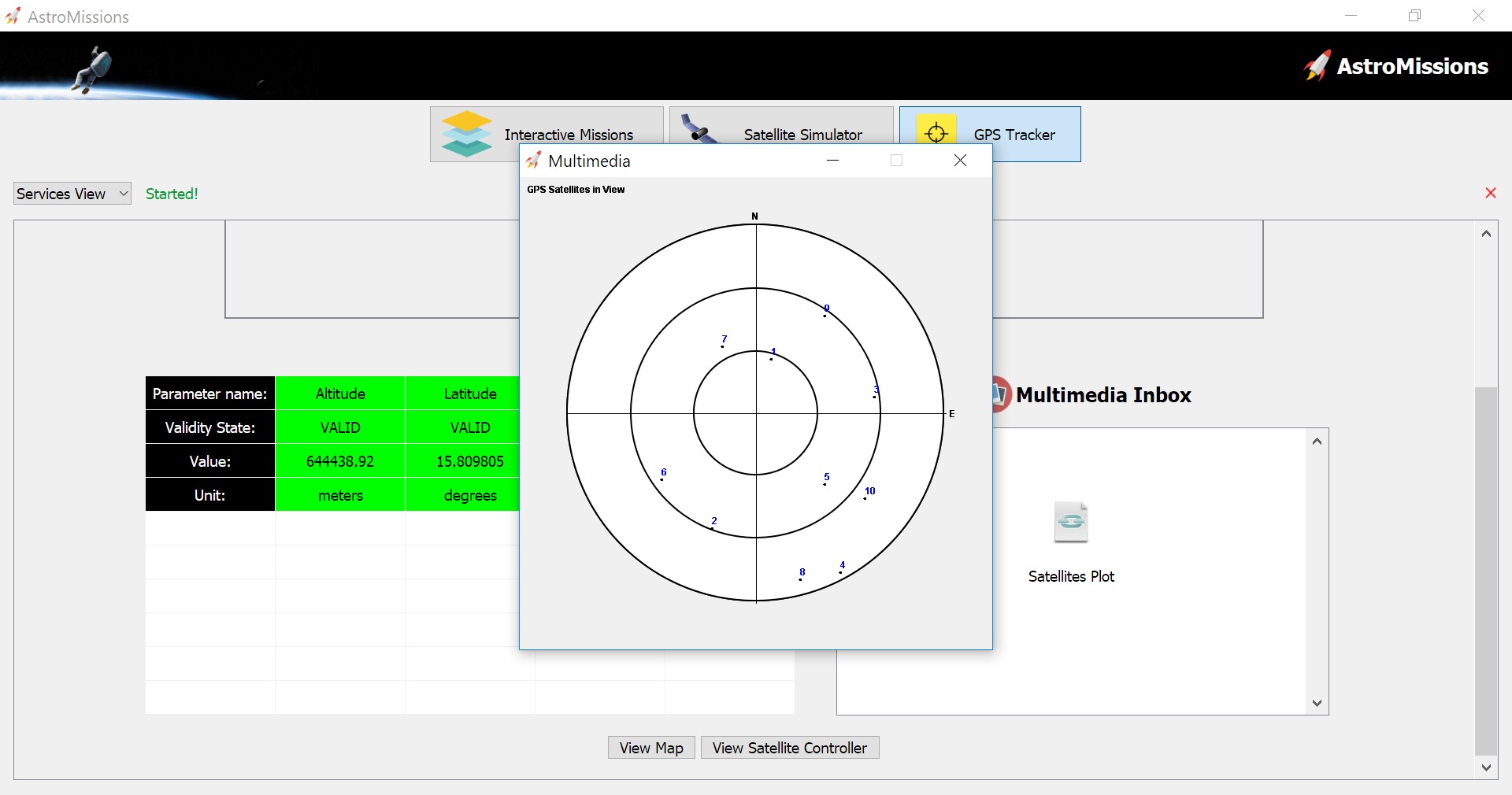
The window will display a plot with the GPS satellites. The dots mark their position and the number above identifies them with the same value as presented in the Satellite Simulator Controller. The position of the satellites will change as time evolves.
6. Put the Satellite Simulator Controller window next to the Multimedia window that is displaying the GPS satellites in view:
7. Change the Time Factor to 10 in and press the button “Set Factor” in order to increase the speed of the simulation
Now it becomes obvious that the GPS satellites in view are changing position. Our satellite is orbiting the Earth with a period of about 97 minutes while the GPS satellites are at a much higher altitude and therefore they have a longer orbital period. The GPS satellites have an orbital period of about 12 hours.
The big changes of the whole constellation are due to the change of our satellite’s position while the small changes of position between the GPS satellites are due to their own trajectory.
Get inspired with a message for humanity by Carl Sagan:
Click here to recommend AstroMissions to your teacher and friends!
References:
[1] By TWCarlson [CC BY-SA 3.0 or GFDL], via Wikimedia Commons